Our Story
History of the Apalachicola Bay, St. Joseph Bay, and St. Andrew Bay Watersheds
Over one hundred and twenty years ago, we breached the historic natural watershed boundary that separated the pristine saltwater environments of St. Joe Bay and St. Andrew Bay from the freshwater ecosystems of the Lake Wimico drainage basin and the Apalachicola River drainage basin with the Gulf Intracoastal Waterway (GIWW). The 20,000 square mile Apalachicola River Drainage Basin collects every drop of water that falls from the sky or bubbles up in springs from the mountains of North Georgia to the Gulf of Mexico in west Georgia and East Alabama. The 75,000-acre Lake Wimico and Marsh were also a major source of freshwater for the Apalachicola Bay ecosystem, and they used to collect, store, filter, and feed this freshwater into the Apalachicola Bay ecosystem via the Jackson River.
Now, however, this direct connection of both of these freshwater drainage basins with the saline environments of St. Joe Bay and St. Andrew Bay is causing catastrophic damage to Apalachicola Bay, St. Joe Bay, St. Andrew Bay, and Lake Wimico. This breach in the natural historic watershed boundary has resulted in extreme sedimentation of large portions of the floor of St Joe Bay with increased turbidity, causing severe damage to seagrass beds and the marine life that depends on them.
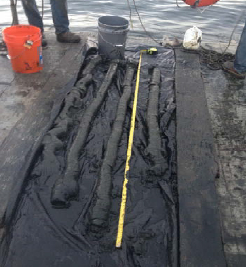
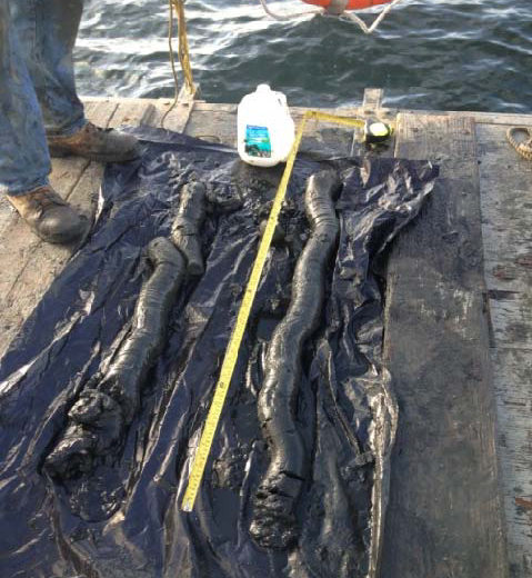
Core samples of sedimentation in St. Joe Bay
Reversed flow, massive diversion, and harmful runoff
Control of stormwater runoff has been a critical and valuable asset to improving coastal water quality nationwide. Yet, here in St. Joe Bay and St. Andrews Bay, we have a massive, uncontrolled, man-made runoff occurring EACH AND EVERY DAY! The World Resources Institute has documented eutrophication and Hypoxia in St. Joe Bay since the 1990s. St. Joe Bay used to be one of the few completely Saltwater Bays in Florida. Unlike the majority of our Bays that are formed by rivers or creeks running through them to reach the Gulf or Atlantic, St. Joe Bay never had any freshwater effluent running into it until we connected St. Joe Bay with the Apalachicola River floodplain through the GIWW and the Gulf County Industrial Canal. Over the years, this uncontrolled runoff has deposited over five feet of river sedimentation onto the floor of St Joe Bay in many areas (See photos of core samples from the floor of St. Joe Bay).
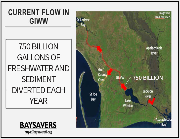
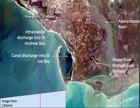
From October 2020 to October 2022, the GIWW diverted more than one trillion three hundred and ninety-five billion gallons of fresh water and sediment away from Apalachicola Bay. This is 1.4 times the TOTAL VOLUME of water in Lake Okeechobee. This is a massive diversion of water and sediment from Apalachicola Bay, where it nourishes, into St. Joe Bay and St. Andrew Bay, where it harms.
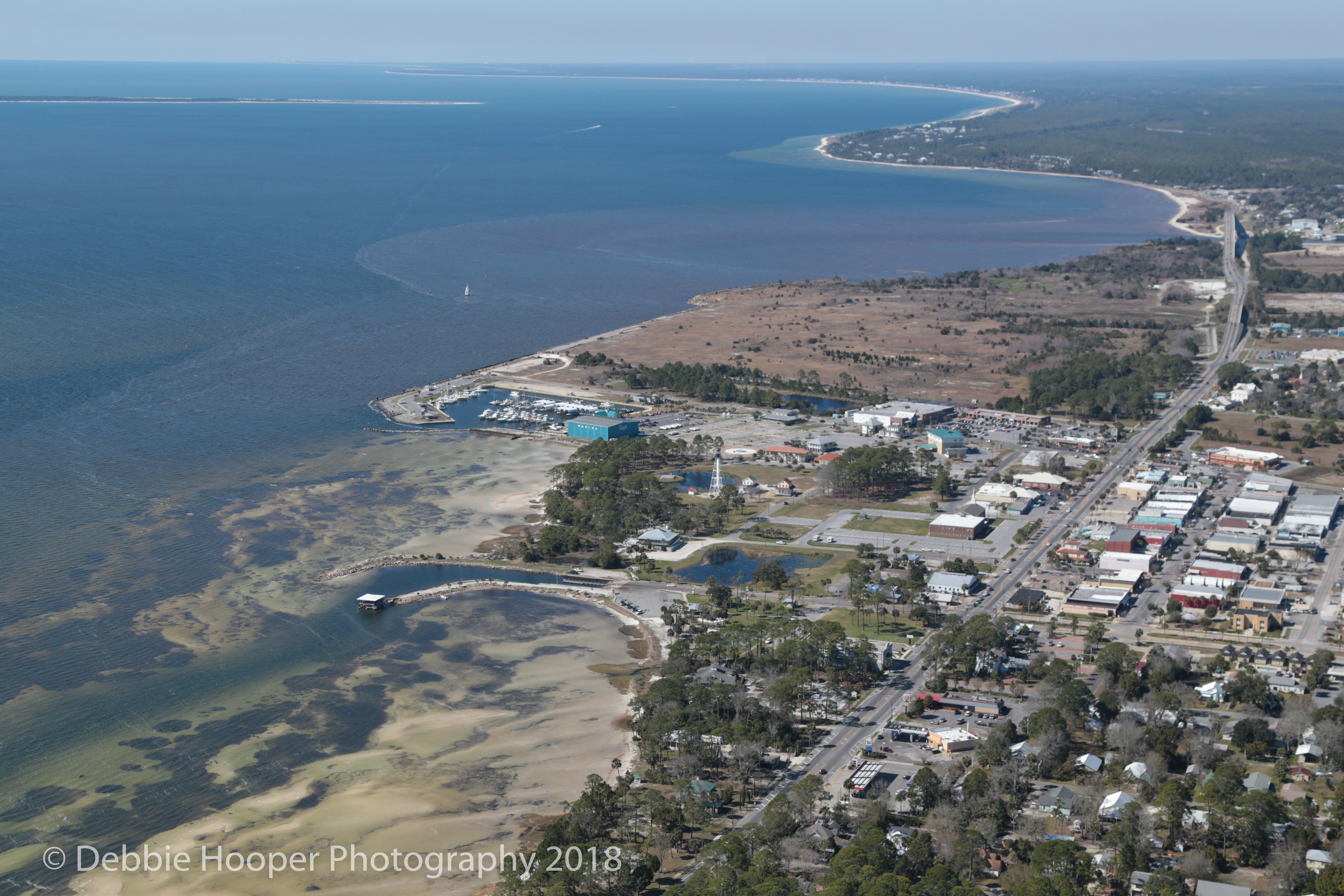
Port St. Joe Conservation
Data & Observations
According to the study done by Northwest Florida Water Management District and Florida DEP, over 750 BILLION gallons of freshwater and sediment are diverted away from Apalachicola Bay and unnaturally discharged into St. Joe Bay and St. Andrew Bay each year (see Link)
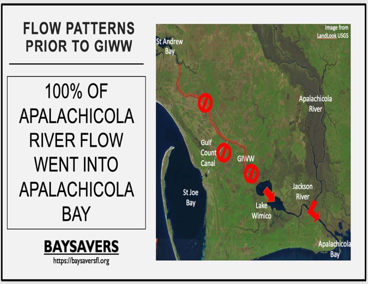
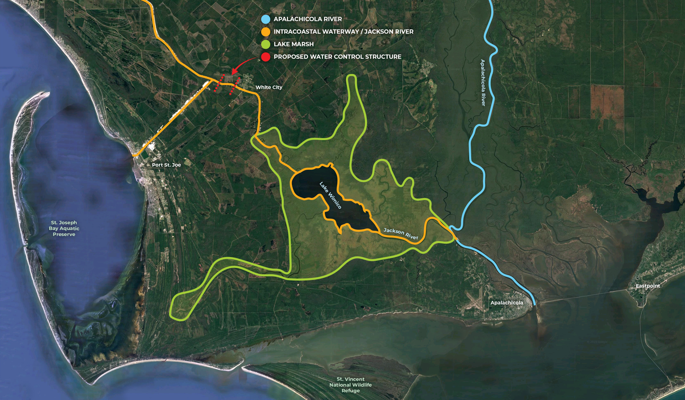
Watershed Boundary Breach
According to USGS and USACE watershed maps (See Link), the watershed boundary between the St. Andrew Watershed and the Apalachicola River Watershed was breached in the vicinity of White City in the early 1900s with the GIWW. This breach reversed the flow of the Jackson River and is continuing to divert 2.06 billion gallons of freshwater and sediment away from Apalachicola Bay and its oyster beds, and is harmfully discharging this same river water and sediment into the seagrass beds of St Joe Bay and St Andrew Bay. This breach has also eliminated the natural historic function of Lake Wimaco and its Marsh and drainage basin, which was to collect, store, filter, and send all its freshwater into Apalachicola Bay. Now, the Lake and its marsh simply serve as a conduit for the unnatural northward flow of river water and sediment away from Apalachicola Bay and into St Joe Bay and St Andrew Bay.
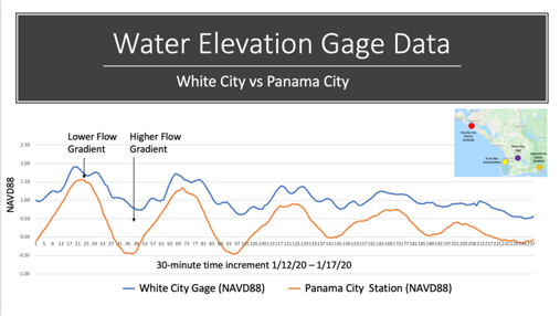
Water & Elevation Gage Data
This data, supplied by existing USACE water gages, shows the gradient between the White City Gage and the St. Andrews Gage. Again, this gradient shows the water flow that we observe, always going out of Lake Wimico toward St. Andrews Bay and St. Joe Bay (See figure 2).
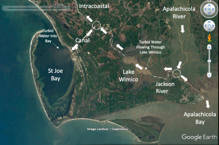
Turbidity
Turbidity in the Apalachicola River Water is a “Dye Marker” in aerial photos. The history of Aerial photos confirms this constant movement of water out of the Apalachicola River, up the Jackson River, through Lake Wimico into St. Andrews Bay and St. Joe Bay (See figure 3).
Thermal Images
Cold river water is easily tracked using Thermal imaging. This thermal Image shows Apalachicola River Water pluming into St. Joe Bay and St. Andrews Bay. It also shows a massive plume entering the Gulf of Mexico from the New Pass in St. Andrews Bay (See fig 4).
Low Water Issues
The ever-increasing frequency of low flow in the Apalachicola River floodplain is well documented. At low flow, the total volume lost is less than high water, but the % lost is much greater, which is significant because oysters are much more at risk in low flow periods.
Storm Surge
Combined with a storm surge, this low water leads to flushing of the entire Lake Wimico marsh with saltwater, with corresponding loss of native Aquatic vegetation.
Canals in the Literature
Beginning with Steward and Gorsline et al. in 1962 and ending with the fact that the most recent SWIM plans for these two watersheds ignore the Canals and their water flow, these canals have been consistently ignored or drastically underreported in the literature. This study has many inconsistencies and errors, yet this 57-year-old study is still the basis for much of the data we use today, including the current SWIM plans for both watersheds.